Here is the link to the blogsite which Michelle Surowiec and I created:
http://musicfest09.blogspot.com/
It features a map pinpointing many of the top music festivals across the U.S., so interested individuals can find the event closest to home and then go on the event website to seek further information.
The blog Michelle and I created has an embeded google map, a news reel feed, and also a continual slide show of music festival photos.
This exercise really made me appreciate ArcGIS.
Wednesday, March 4, 2009
Monday, February 23, 2009


Tuesday, February 17, 2009

Tuesday, February 3, 2009
Ten Times Japan

^Gridlocked

^Off Limits

^Building Blocks

^Ink over Text
 ^Dark Side, Light Side
^Rising Sun

^Jpn

^Haiku
 ^Computer Screen
^Big Nippon
Monday, January 26, 2009
Classifying Italian Ecosystems
The following three maps were created using GIS data from the World Wildlife Fund:
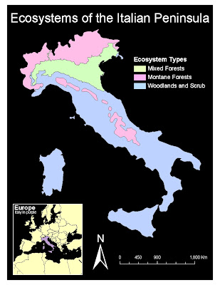
The above map shows a very basic distribution of terrestrial ecosystems of Italy.
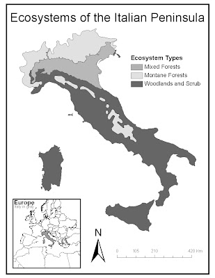
The map above is simply a black and white version of the previous map.
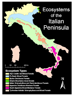 This last map was created to take a more detailed look at Italy.

The above map shows a very basic distribution of terrestrial ecosystems of Italy.

The map above is simply a black and white version of the previous map.
 This last map was created to take a more detailed look at Italy.
 This map series was particularly fun to create. Among the GIS data files available, I discovered a file belonging to the World Wildlife Fund and decided to explore its various properties. It subdivided the globe into various regions, raging from very broad biomes such as "Tropical" to incredibly specific ecosystems such as "Apennine Deciduous Montane Forests."
My first two maps are essentially identical, except one is designed to fit in with my blog's color scheme while the other is a printer-friendly black and white. Here the ecosystems are very broad in definition, dividing all of Italy into 3 different areas: mixed forest, montane forest, and woodland scrub. The results show that forest are located along mountain ranges (more apparent if mapped with elevation as a second variable) and also more common along higher latitudes.
The last maps takes it a step further and subdivides the three original areas into more descriptive regions described by vegetation type. Again, given a second variable, it would be interesting to see how elevation plays a role in the distribution of the various ecosystems, specially along the Apennines and the Alps. Again, vegetation varies by latitude, so regional differences such as temperature and precipitation would make for interesting variable to create an overlay map.
Sunday, January 18, 2009
Election 2008

 This second map (above) was created in order to visualize more information concerning the 2008 election. I found some interesting exit poll statistics on CNN, which showed that the majority of White Americans preferred McCain to Obama, not limited by gender, income, or education level; consequently, I decided to map population density of "Non-Whites" by state. I combined Blacks, Hispanics, and Asians in order to keep the map simple and easy to read. The following were considered swing states during the 2008 election and are accompanied by the number of contributing electoral votes in parentheses:
- Nevada (5)
- Colorado (9)
- New Mexico (5)
- Iowa (7)
- Missouri (11)
- Mnnesota (10)
- Ohio (20)
- Virginia (13)
- Florida (27)
- New Hampshire (4)
The map itself attempts to build upon the NY times map by making more use of the empty space while simultaneously displaying additional data concerning the 2008 election within a geospatial scale. Colors and Map Key were altered to better fit the purpose of the map.
Wednesday, January 7, 2009

Subscribe to:
Posts (Atom)

